The Roadless Coast
“The edges of any landscape,” writes Barry Lopez in his landmark book, Arctic Dreams, “quicken an observer’s expectations. That attraction to borders, to the earth’s twilit places, is part of the shape of human curiosity.”
When the border in question is the nebulous zone between land and ocean, the resulting curiosity is even more intense. A wild sea beating against a wild shore is certain to bring out the curious nature in any observer.
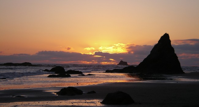
 The roadless coast between Cape Flattery and Ruby Beach, on the west coast of Washington’s Olympic Peninsula, is among the last of the large wilderness coastlines in the contiguous United States. Almost everywhere else, from Maine to Florida, along the fragile beaches of the Gulf Coast and up and down the Pacific shore, development and centuries of human “improvements” have changed the nature of the coastal environment. Here on the edge of the continent, however, it is still possible to move through a border region between land and sea that is largely intact, that still retains all the wonder and power that is missing everywhere else.
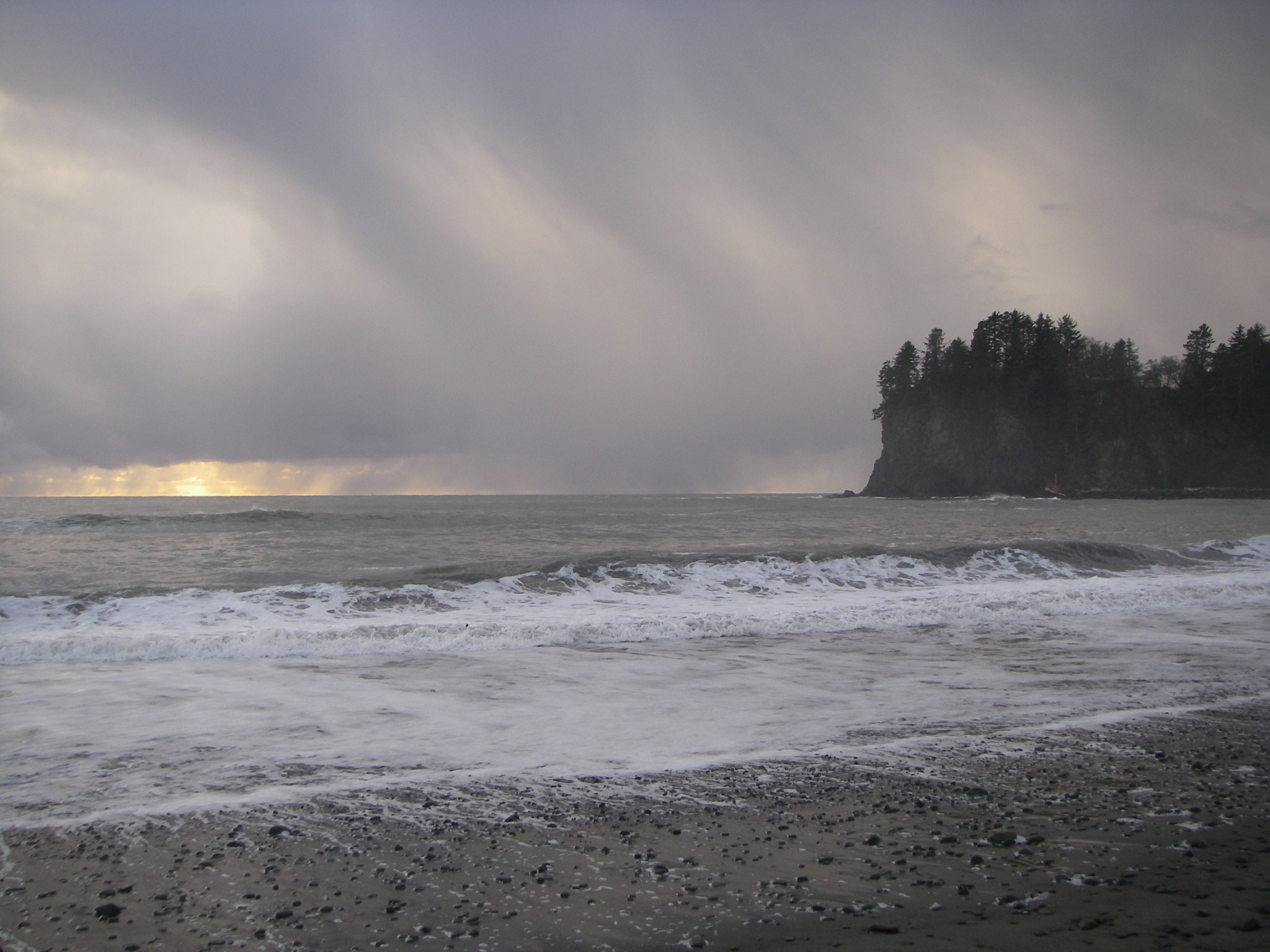
Highway 112 runs along the Washington side of the Strait of Juan de Fuca and ends in the town of Neah Bay. Ruby Beach, the place where Highway 101 angles back toward the coast once again, lies 62 miles to the south. Although there are a few roads that make their way to the water’s edge from the interior, most notably at the Native village of La Push, there aren’t any that follow the rugged shore. The land between these two points is almost entirely National Park or Indian reservation, undeveloped, pristine and wild.
All this is not to say that the area doesn’t get its share of visitors. During the summer months, backpackers frequent the area, muscling their oversized ruck sacks through the soft sand and up the steeper sections of the trail. The path hugs tight to the shore for much of the way, with sweeping views of the offshore rocks and within the constant sound of the surf. Still, when the way becomes too steep and the headlands jut out into the sea, there are significant portions of the path that travel inland, in an attempt to avoid these stony hazards that are impassable on foot.
Although these sections of the coast may not be suited to hiking, they are custom-made for the sea kayaker. Even when the way is clear along the beach, the best parts of the coast are the portions away from the trail, accessible only by sea. To see the stacks and the rock gardens from shore is one thing; to travel among them and taste the salt of the waves on your lips is quite another.
Cape Flattery – Shi Shi Beach
Paddling west along the Strait of Juan de Fuca between Neah Bay and the cape, it is easy to see the changes in the shoreline as it transitions between the protected areas common to interior waters and the swells and surges of the open coast. Beaches become smaller and farther apart, the rocky outcroppings are more exposed to the force of the waves and the swells become larger and more pronounced. Rounding the tip of the land, the compass needle begins to swing toward the south and the coastline turns to ramparts of stone, high cliffs that resemble castle walls, protecting the land from the sea’s advance.
The currents here at Cape Flattery are among the trickiest anywhere along the coast. Because of the interplay of tidal flow through the straits, the predominantly southern flow of the coastal current, and the constantly changing force of the wind, the water here can be confused and dangerous.
Tatoosh Island rises from the water just a ten-minute paddle off to the northwest, a stone sentinel at the entrance to the straits. The lighthouse is still operational and some scattered outbuildings remain atop the windblown rock, but the island itself is part of the Makah nation and landings are prohibited. Even so, a side-trip toward the island is still in order, if only to see the wildlife that congregates in the area. Vast numbers of gulls, terns, cormorants and guillemots fill the sky and the rocks. Bald eagles swoop and soar on the sea airs. Sea lions cluster on the offshore rocks, snarling and bellowing as they vie for limited space. Once the site of native whaling camps and the occasional raucous potlatch, the beach on the eastern side of the island has been returned to the animals of fur and feather.
On the mainland coast here at the corner of the country, sea caves of all shapes and sizes cut into the primordial rock. Some of these caves are little more than vertical cracks in the stone walls. It is necessary to use hands to move a kayak through the barnacle-encrusted passageways; there is simply no room to swing a paddle. There are a few places where it is possible to enter one cave and exit by another, moving slowly through dark passages where few people have ever been.
Other caves are much larger. The biggest, just north of Cape Flattery, is about 60 feet tall, 200 feet deep, and has two separate entrances. Behind barrier rocks and in the shelter of dense kelp beds, the water inside the cave is often calm and smooth, even when conditions outside are anything but benign.
Just south of the cape, standing rocks and offshore stacks dominate the coastline. The largest stone finger, the Juan de Fuca Pillar, was used as a landmark by Captain George Vancouver as he prepared to enter the straits and begin his exploration of Puget Sound. Navigating a kayak through the maze of arches and rock gardens takes some paddling skill and a modicum of daring, but the route is well worth the effort and is excellent preparation for the rest of the coast that lies ahead.
After three or four miles of shallow coves and scalloped beaches of sand, the coastline cuts in sharply at Waatch Point. This rocky reef marks the entrance to Makah Bay, where two rivers empty into the salt water at Hobuck Beach. Three miles of open water lie between Waatch Point and Anderson Point, at the southern end of the bay. A crossing often seems to take longer than it should, a product of current rips and an almost total lack of proximate reference points. There are some isolated rocks scattered along the route, but they are few and widely spaced, and make poor trail markers.
Shi Shi Beach – Cape Alava
Once past Anderson Point and its neighbor to the south, Portage Head, the coastline changes radically. The rocks, caves and stacks that have defined the border between water and land up to this point now give way to a sweeping arc of sand. Over the years, Shi Shi beach has been home to settlers, hippies and local tribes. These days, however, Shi Shi (rhymes with “aye-aye”), is the northern boundary of the coastal portion of Olympic National Park. This is the first part of the coast that most backpackers see; the trail starts in the woods behind Anderson Point and breaks out onto the sand just south of Portage Head. Camp sites are easy to find all along this coast, clearings of various shapes and dimensions tucked under giant spruce and cedar trees at the edge of the dark, green forest. A massive tangle of drift logs that runs the entire length of the beach marks the high water point.
Shi Shi Beach stretches almost three miles from top to bottom, its southern end defined by the distinctive outline of the Point of the Arches. The parapets of rock are cut through with windows of air, arches that can be paddled under at high tide or explored on foot when the water is low. Because the point extends from shore at a right angle, the swells wrap around the tip of the headland, making the north side of the point one of the best kayak surfing spots along the entire route.
Another extensive system of rocks and pillars punctuates the shoreline south of the Point of the Arches. The paddling here is much like that near Cape Flattery: skill and timing are essential when the water is rough and most of the area is not visible from the trail. After two miles the land turns to beach once more, a long sweep of yellow that stretches south toward the Ozette River and Cape Alava. Offshore, several stacks rise from the water and help to gauge progress along the route. Father and Son, one of the more easily identifiable of these, lies about a mile from land and consists of one large stack and a smaller one, joined at the base. To paddle on the ocean side of these majestic towers and to see the waves exploding onto the stone is a reminder of the forces of nature that continue to shape this place.
At the mouth of the Ozette River, less than two miles north of Cape Alava, a native village once stood. Cedar longhouses were clustered between the river and the ocean, home to a tribe that exists no longer. The entire site was inundated by a massive mud flow and hidden for over 500 years until it was uncovered after another flood in the winter of 1969. Even after being buried for such a long time, the buildings and artifacts were surprisingly well-preserved because of the anaerobic environment created by their muddy tomb. Over 55,000 separate items, many in almost perfect condition, were removed and relocated to Neah Bay, where they are now housed in the Makah museum. After the excavation was completed, the remaining structures were again covered in mud, this time on purpose, to preserve what was left and to protect it from looting.
Cape Alava extends west into the Pacific almost as far as Cape Flattery, but because of the extensive system of offshore islands and kelp beds, the water here tends to be less challenging. There is a trail that connects Cape Alava to Lake Ozette, a popular hiking route in the summer that sees a significant number of visitors throughout the other times of year as well. The Ozette Triangle is a nine-mile loop that winds from the lake across a mostly boardwalk trail to Cape Alava, then follows the beach southward to Sand Point, where another trail meanders back to the starting point. Because of its accessibility and relatively easy terrain, this area has more backpacking and day-hiking traffic than anywhere else on the roadless coast. Camp sites are plentiful and the northern portion of the cape, sheltered from the swells by nearby Tskawhyah Island, is the preferred kayak landing area.
Cape Alava – La Push
A shallow gradient and extensive tide pools are the features that draw so many hikers to the three-mile stretch between Cape Alava and Sand Point. The wide, rocky shore that makes a hike so interesting makes it problematic for kayakers, however. Although it is fairly easy to launch and land anywhere along this portion when the tide is high, low water exposes a treacherous rock pile of epic proportions, almost all of it covered with slippery seaweed and kelp. There are points of interest along the way, most notably the ancient petroglyphs at Wedding Rocks, but because of the difficulty inherent in carrying a kayak across the ankle-twisting terrain, it is best to traverse this section when the tide is up, making it past Sand Point before the level drops too low.
Once past Yellow Banks, the beach is reachable without much drama regardless of tide height. Offshore stacks and close-in rock gardens come back on the scene again just north of Kayostla Beach, where excellent camp sites dot the forest fringe near the Norwegian Memorial. Almost a dozen creeks of various sizes empty into the salt water between here and La Push, each of them providing protected landing zones and flat ground with ample tent spaces.
As the number of sea stacks and rocky reefs increases, it becomes easier to pick out a route that runs between them and the beach, a paddling path where the swells are muted by the offshore terrain. In this protected zone, it is possible to wander from one feature to the next, hopscotching from rock to rock, out of the full force of the waves.
The final four miles above the town of La Push parallels Rialto Beach. Popular with hikers, it is nevertheless a difficult place to land a kayak because of its significant exposure to swells and steep, dumping waves. The best way to travel this stretch is usually well out from shore, staying outside of the surf zone in all but the most favorable of conditions.
There are several landing options at La Push. Choosing the best one is a matter of observing the swell action and using the convolutions of the shoreline to shield your approach. In most instances, the route between Little James Island and Gunsight Rock is a relatively straightforward approach that may require some surfing ability but is usually free of large, crushing breakers. If the swell is out of the north or northwest, however, it might be best to take a wide path around James Island and come ashore at First Beach, next to the Quillayute river mouth jetty.
La Push is a sleepy reservation town, connected to the outside world by a two-lane blacktop that stretches east toward Highway 101 and the rest of the Olympic Peninsula. There is a store here and a café that is open during the high season, along with seaside cabins that can be a welcome break from tent life.
La Push – Ruby Beach
The Quillayute Needles, a collection of stacks and arches just south of La Push, give some indication of the wonders that await kayakers as they proceed toward the end of the route. Crying Lady Rock, the most prominent of the group, is a stout battleship of a sea stack, surrounded by intricate rock gardens and other, smaller towers.
Between Taylor Point and Toleak Point, the Giants Graveyard is one of the most enjoyable kayaking venues anywhere. Paddling pace slows to a virtual crawl here, simply because there is so much to see. While hikers trudge along the soft sand and pick their way through the forest away from shore, kayakers have the unique luxury of coastal exploration that their terrestrial counterparts will never know. Arches abound, some of them rising 40 or 50 feet above the water. The rocks are sculpture, works of art that have taken millennia to create, still incomplete, still under construction.
Goodman Creek connects with the ocean between two rock pillars, like a scene from a fantasy. While most rivers and creeks converge with the salt water across sand bars and with braided channels, the mouth of Goodman Creek looks more like a carved doorway, a grand portico of stone. Turning into the rock-framed passage and paddling up the creek, it doesn’t take long before the sound of the surf disappears and the sea is completely gone. The surroundings seem more like a mountain lake than anything else, with grasses lining the banks and trees overhanging gravel bars and cool, dark coves along the shore. A small waterfall empties into the creek from the east at the spot where the trail crosses, where those less fortunate, those without sea kayaks, are consigned to travel.
Mosquito Creek, about two miles to the south, is an ideal camp spot. Most of the backpackers choose to pitch their tents in the woods on the south side of the creek, away from the water, leaving a few choice spots along the creek in the rocks above the high-water mark. Although the surf can be fairly large here at times, the summer landing conditions are not too demanding and the sandy beach is free of obstacles.
Farther to the south, Hoh Head represents the last major obstacle on the way to Ruby Beach. Beyond here, the stacks thin out and the inshore rocks give way to short cliffs and sand, making the rest of the route fairly straightforward. The Hoh River makes an appearance on this section, and an alternative ending to the trip at Oil City requires a simple paddle upriver to the road end just inside the park.
Ruby Beach is a steep gravel landing zone that can be difficult to negotiate if the surf is big. There is a rock garden near the north end of the beach that offers some protection and with good observation and planning, a take-out here doesn’t usually present any problems. The trail from the beach to the parking lot is a bit of a haul, but after over 60 miles of paddling, a short uphill climb doesn’t feel all that bad.
It is a combination of luck and rare governmental foresight that has left us with this national treasure that is the Olympic roadless coast. Perhaps the greatest thing about this stretch of shoreline is that it is always changing, different with every tide and time, making each trip here a unique and priceless excursion, sure to shape any kayaker’s curiosity.
_________________________________________________________________
Makah Information:
An alternative starting point for the coastal traverse is Hobuck Beach on the Pacific side of Cape Flattery. The beach itself has some good surf, especially in the summer, which makes it a popular choice for day-paddling as well.
Hobuck Beach Resort
Phone: 360-645-2339
Fax: 360-645-3784
Email: [email protected]
Olympic National Park:
Permits are required for overnight stays inside the park. Wilderness Camping Permits are $5, with an additional $2 per person/per night fee. They can be purchased in Port Angeles at the park’s visitor center or at the Interagency Information Center in Forks. The park puts a quota on overnight visits between Seafield Creek and Yellow Banks from May 1 – Sep 30. Reservations can be made up to 30 days prior to first day of trip. Call (360)565-3100 or www.nps.gov/olym for reservations and info.
Bear-proof containers are required for food and are available for rent from the park service.
(This article ran in the April 2010 edition of Sea Kayaker magazine. It was hard to see that one go…)
About Ken Campbell
New Release
A story of sea kayaking and science on the rugged coast of Alaska. Coming – Spring 2014.
Follow Us On Instagram


