Ikkatsu daily report – Shi Shi to Wedding Rocks
I got a call from a Seattle reporter yesterday morning who seemed interested in talking with us about the issue of debris in general – not just the tsunami material – a deeper and more complicated topic. We spent twenty minutes or so on the phone, a good conversation, and I could tell that he saw this as an important subject that people need to be aware of. He said he’d call me back to set up a time to talk on camera, but then Seattle got zapped with an electrical storm most of the day yesterday and the issue of beach debris took an immediate and precipitous slide down the media priority totem pole. Such is life in the fifth estate… one minute it seems like everyone wants to talk to you, the next minute you’re just not that interesting. Ah well, on with the story…
July 5, 2012
Before we launch from Shi Shi, we do another survey at the south end of the beach. (One of the basic rationales for the Ikkatsu project is that we will focus our efforts on beaches that are difficult for people to access on foot; of course, Shi Shi is not one of these. The reason we thought it was important to do a survey here was that, simply because so many people have hiked here, and have formed a connection with the place, it might bring the problem home in a way that simple statistics about a more remote beach would not.)
It’s such a wide area, from the water to the high tide line, that it doesn’t seem cluttered at first. There are certainly other beaches that have collected more debris than this one, but there is still plenty of plastic about, much of it styrofoam. The little white chunks are mixed in with the kelp snarls on the sand and we sift through the slimy piles, counting the pieces as we come across them.
After the survey is complete, we go for a walk to visit a few of the smaller coves just south of Shi Shi. When the tide comes in, these coves will be cut off to foot travel, but for now, it’s not hard to round the points that separate one from the next. These beaches are more gravel than sand, steeper than Shi Shi, and the debris is more focused than at the wider beach to the north. We find some larger items: a six-foot piece of closed-cell foam with Kanji lettering, shoes, large fish-attraction buoys and what appears to be a Japanese pesticide sprayer that is likely to have gotten here as a result of the tsunami. It’s definitely a residential-type item, not something you’d find used on a ship, so it seems reasonable to assume that it came here after the wave hit. We take many photos, then head back to the boats.
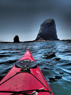
The paddle from Point of Arches to Cape Alava is an easy one, not much wind, blue skies and a soft swell. We pass right next to Father and Son, one of the more distinctive pair of offshore stacks along the route and it only takes about 90 minutes before we’re rounding the sand bar at the tip of Cape Alava. Our destination is Wedding Rocks, about a mile further south, but we stay close to shore here watching the hikers as we slip past.
We’re in the Ozette Triangle now, the most-visited section of this entire roadless coast. It’s a 9-mile hike from Lake Ozette to Cape Alava, then down the beach to Sand Point, and back to the ranger station at Lake Ozette once again. The loop is popular with overnighters as well as day-hikers and with the weather being so nice, there’s no shortage of people about. Families and solo hikers, fit and not-so-much: it’s the height of the busy season.
We make camp at a beachside spot just north of Wedding Rocks, our boats scraping the sand right at high tide. Because of the extensive reef that rings this section of coastline, we’ll have to come and go at high water… to try to launch at any other time would entail an ankle-snapping stagger through tide pools and seaweed-covered rocks.
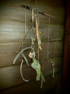
After dinner, we walk up the shore to Cape Alava to visit the bone house. It’s a cedar-plank shack just up from the ranger cabin that is home to a collection of shells and bones that have been found on nearby beaches. Whale ribs, sea lion skulls and a variety of vertebrae, phalanges and other bone fragments. The floor is muddy and the walls tilt at odd angles in places, but despite the somewhat strange collection, the place seems peaceful somehow. As if it belongs there. There’s a plaque at one end that marks the building (and the coast itself), as being dedicated to the Makah people and as the sun sets in a quiet explosion of reds and orange, I try to picture what this stretch of wilderness used to look like.
When the village of Ozette stood in this spot… longhouses and canoes, cooking fires and fishermen. Before the National Park. Before the campground families of escaped urbanites. Before plastic.